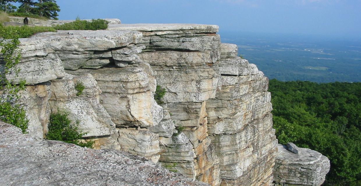
Mossy Glen/Long Path/Castle Point/Hamilton Point Loop
This loop hike follows an attractive stream, climbs to panoramic viewpoints from dramatic cliffs, and passes by a fascinating waterfall.
Take the New York State Thruway to Exit 18 (New Paltz). After paying the toll, turn left onto Route 299 and continue west through the Village of New Paltz. When you cross the bridge over the Wallkill River at the west end of the village, continue ahead on Route 299 (do not turn right towards the Mohonk Mountain House). In another 5.6 miles (from the Wallkill River bridge), Route 299 ends at a T intersection with Route 44/55. Turn right here and follow Route 44/55 as it negotiates a very sharp hairpin turn and climbs to pass under the Trapps Bridge (a steel overpass). Continue for about three miles past the Trapps Bridge to the entrance to Minnewaska State Park Preserve, on the left side of the road (a $7 parking fee is charged at the gatehouse). Immediately turn right and proceed for 0.2 mile to the Awosting parking area.
Find the kiosk at the rear of the parking area, and continue past the gate onto the Lower Awosting Carriageway (also known as the Peters Kill Road). Almost immediately, you'll see a sign on the left that marks the start of the yellow-blazed Mossy Glen Path. Turn left and follow this trail, which passes through an attractive forest of hemlock and mountain laurel. The trail soon approaches the carriageway, then turns sharply left and descends to the Peters Kill, which it crosses on a footbridge. This spot is particularly beautiful, with a large pool in the stream just downstream.
Follow the yellow-blazed trail as it turns right a short distance beyond the bridge and begins to run parallel to the stream. For the next mile, the trail remains close to the stream, at times coming out on open rock slabs which slope towards the stream. Rhododendron and white pine may be found along the trail, together with hemlock and mountain laurel.
After passing through a relatively open area, with stunted pitch pines and an understory of blueberries, the Mossy Glen Path ends at the blue-blazed Blueberry Run Path. Turn right and follow this blue-blazed trail downhill, soon crossing the Peters Kill on another footbridge. The trail climbs rather steeply to cross the Lower Awosting Carriageway, then continues through mountain laurel and hemlock. After another steep climb, the Blueberry Run Path ends at a junction with the aqua-blazed Long Path.
Turn left and follow the Long Path, which soon begins to run close to the edge of the ridge, coming out occasionally on open rocks, with views over Litchfield Ledge to the east. (You'll be following this ledge later on in the hike.) In about three-quarters of a mile, you'll reach a power line. Follow the trail as it turns right, runs along the power line for a short distance, then turns left and continues on an old woods road. The trail soon begins to descend. As it goes down a badly eroded section of the old road, the trail has been rerouted onto a footpath to the left. At the base of the descent, turn left onto a grassy woods road, which soon reaches the Lower Awosting Carriageway.
Turn right and follow the Lower Awosting Carriageway, crossing an earthen causeway over Fly Brook. Just past the brook crossing, be alert for a double aqua blaze on the left. Follow the Long Path as it turns left, leaving the carriageway, descends briefly, then ascends steadily over slanted slabs of conglomerate rock dotted with pitch pines. It turns left, crosses a small stream, and continues to climb over slanted rock ledges. From the top, the Catskills may be seen in the distance.
After a short but steep descent, the trail comes out on an open rock ledge. To the right is Huntington Ravine, with Lichtfield Ledge beyond. You'll hear the sound of falling water, as Rainbow Falls is just below. The trail soon bears sharply right and descends very steeply, with cliffs to the right. At the base of the descent, Rainbow Falls comes into view. Here the water drops from overhanging rock ledges, forming a cool mist. You'll want to spend some time at this beautiful spot!
The trail now bears left, descends to cross a small stream, then climbs steadily to reach the Upper Awosting Carriageway. It crosses the road, bears left to climb a ledge, then turns right and runs parallel to the edge of the escarpment. Soon, you'll reach a rock ledge to the right of the trail that offers a panoramic view, with Huntington Ravine just below, and the Catskills in the distance.
The Long Path enters a dense forest of hemlock and mountain laurel, then bears left and continues through an area of sparser vegetation, with pitch pines growing from cracks in the conglomerate bedrock. There are some short, steep descents where you'll need to use your hands.
Finally, you'll come out on a wide, open rock ledge that affords a panoramic view of Lake Awosting., with Sam's Point beyond. From here, the trail bends left and soon begins to run along the edge of a cliff. To the right, you can see Castle Point - your next destination.
The Long Path soon reaches an intersection with the Castle Point Carriageway. Turn left and follow the carriageway for about half a mile, passing numerous viewpoints to the right. Immediately after the Blueberry Run Path leaves to the left, you'll reach Castle Point - the highest viewpoint in the park. The view from here is spectacular, with the Wallkill Valley to the left and Lake Awosting to the right. Again, you'll want to take a break and enjoy the views.
Follow the aqua-blazed Long Path as it descends precipitously from Castle Point over steep ledges. You'll need to use your hands here. After a more gradual descent, you'll reach the Hamilton Point Carriageway. Here, the Long Path turns right, but you should turn left onto the carriageway, which is marked with "H"-on yellow-diamond blazes.
In another half a mile, you'll reach Hamilton Point - another fabulous viewpoint, with deeply-fissured rocks separated from the main cliffs. The wall of cliffs in the distance to the left is the ridge of Gertrude's Nose. Continue along the carriageway, passing more spectacular views to the left. In about a mile, you'll cross under a power line. Next, you'll arrive at Echo Rock, a particular outstanding viewpoint. Just beyond, the carriageway briefly splits into two routes, which quickly rejoin each other. You'll soon notice a line of cliffs to the left.
Continue ahead (bearing right) at the next junction, and then bear left at the following junction, joining the yellow-diamond-blazed Millbrook Mountain Carriageway. In another 0.2 mile, turn left on the Minnewaska Carriageway, which circles Lake Minnewaska. When you reach the swimming area, continue ahead and climb to an intersection with the Sunset Carriageway. Turn sharply left and follow the Sunset Carriageway, which descends on switchbacks, passing a broad viewpoint. At the base of the descent, turn right, cross the bridge over the Peters Kill, then turn left at the gatehouse and follow the park access road back to the Awosting parking area where the hike began.
- Login or register to post comments
- Printer-friendly version
- Send by email


Comments
Terrific hike!
I did this hike this past weekend with my 14 year old daughter and 16 year old son. We used the alternate starting point from Jenny Lane Trailhead and hiked in Jenny Lane Trail. My daughter was happy because of all the blueberries to pick and eat while walking in this way.
Getting down to the falls was a bit of a challenge for my daughter since she's the shortest of the three of us, but we managed and enjoyed the cooler temps and cool water off the falls.
When we got up to Castle Point, I showed my kids where the trail went over the edge of the lookout. It had taken us 5 1/2 hours to reach that point and we were all feeling pretty tired, so we decided to skip the steep downward descent and hike over to Hamilton Point. We took the Castle Point Carriageway back from there and still got to enjoy plenty of views on our way back. It took us 8 1/2 hours to complete our hike.
I do hope to try to use the trail between Castle Point and Hamilton Point one day. It looked like a great challenge!
Awesome Hike