Mohonk Preserve


Park Overview:
A preserve with over 100 miles of carriage roads and trails offering easy, scenic hikes and rugged rock scrambles requiring the use of hands as well as feet.
Park Description:
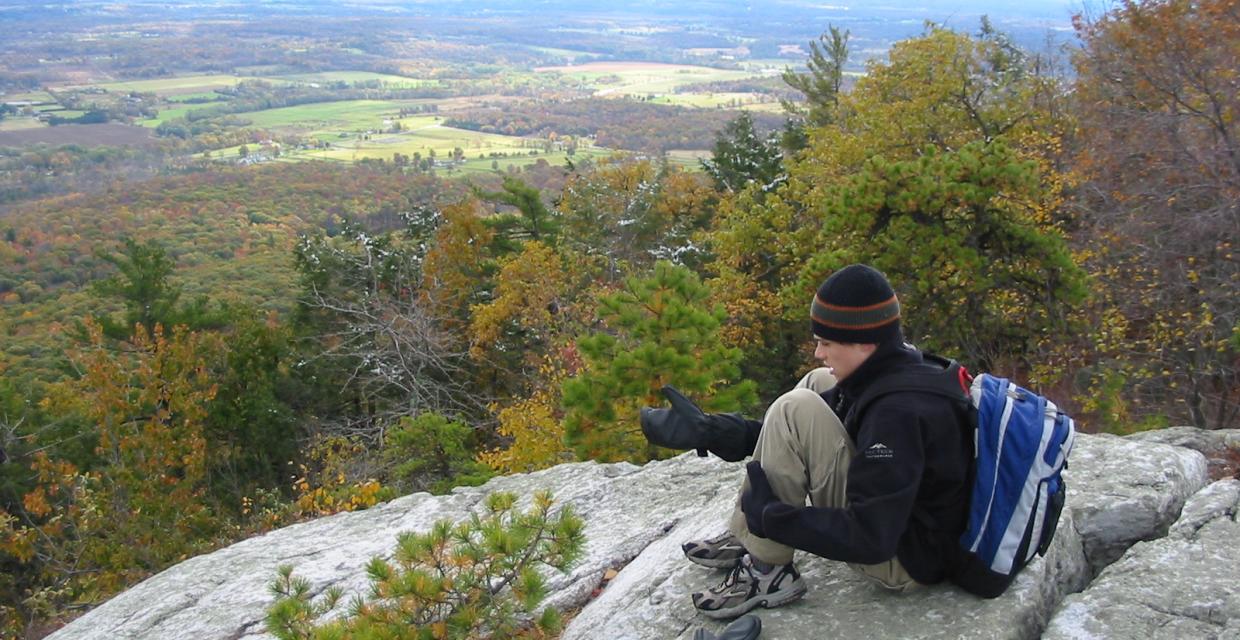
The Mohonk Preserve is New York State's largest not-for-profit privately owned nature sanctuary. Its 6,400 acres extend for nearly eight miles along the Shawangunk ridges, from Bonticou Crag to Millbrook Mountain, and includes cliffs, forests, fields, ponds, and streams.
Hiking on preserve lands is by day-use [or annual] permit, for which a fee is charged. Preserve Permits, which may be obtained at the visitor center or from rangers on patrol, also allow one to hike on Mohonk Mountain House lands.
Trails Overview:
There are over 100 miles of carriage roads and trails. Walking in the preserve ranges from easy, scenic strolls on carriage roads to rough scrambles over boulders, through crevasses, and across open ledges. Only a brief indication of the possibilities can be suggested; hikers are encouraged to go maps in hand and make their own discoveries.
- Millbrook Ridge Trail [3.0 miles; light blue]: This trail, at the southern end of the preserve, is one of the loftiest in the Shawangunks, skirting along the crest atop some of the Shawangunks' taller cliffs: the Near Trapps, Bayards, and Millbrook Mountain.
- The trail starts on the Trapps carriage road, accessible from the West Trapps parking area.
- Overcliff and Undercliff Roads [5.4 miles; directional signs only]: This easy, level walk on carriage roads loops around the dramatic scarp of the Trapps cliffs, the hub of the southern preserve. Undercliff Road is especially remarkable, considering it was solely built to capture the scenic panoramas of the Wallkill Valley and the cliff above.
- Trailhead at West Trapps parking area.
- Bonticou Crag: The top of Bonticou Crag [1,194 feet], at the northern end of the preserve, is a far more rugged and dramatic viewpoint than its modest height would suggest. The shortest route is to start on the Crag Trail [red], but a map may be needed to guide a hiker to the top. The Bonticou Ascent Path [yellow] is a rock scramble that requires agility, confidence, and the use of hands as well as feet. A longer but much easier ascent is along the Northeast Trail [blue].
- Trailhead at Spring Farm Entrance.
Wheelchair users will need a special overland wheelchair, as the trails are shale-surfaced. There is handicapped parking at most trailheads.
Park Acreage:
6400.00 acresMunicipality:
GardinerA preserve with over 100 miles of carriage roads and trails offering easy, scenic hikes and rugged rock scrambles requiring the use of hands as well as feet.
The Mohonk Preserve is New York State's largest not-for-profit privately owned nature sanctuary. Its 6,400 acres extend for nearly eight miles along the Shawangunk ridges, from Bonticou Crag to Millbrook Mountain, and includes cliffs, forests, fields, ponds, and streams.
Hiking on preserve lands is by day-use [or annual] permit, for which a fee is charged. Preserve Permits, which may...
Park Acreage:
6400.00 acresMunicipality:
GardinerContact Information
Web Link:
Mohonk PreservePhone:
(845) 255-0919Fees:
Yes, click on 'Contact Information' for further informationDogs in park:
Dogs on leash
Hike Checklist:
Whether you are going for a day hike or backpacking overnight, it is good practice to carry what we call The Hiking Essentials. These essentials will help you enjoy your outing more and will provide basic safety gear if needed. There may also be more essentials, depending on the season and your needs.
The Essentials
Hiking Shoes or Boots
Water - Two quarts per person is recommended in every season. Keep in mind that fluid loss is heightened in winter as well as summer. Don't put yourself in the position of having to end your hike early because you have run out of water.
Map - Know where you are and where you are going. Many of our hiking areas feature interconnecting network of trails. Use a waterproof/tear-resistant Tyvek Trail Conference map if available or enclose your map in a Ziplock plastic bag. If you have a mobile device, download Avenza’s free PDF Maps app and grab some GPS-enhanced Trail Conference maps (a backup Tyvek or paper version of the map is good to have just in case your batteries die or you don't have service). Check out some map-reading basics here.
Food - Snacks/lunch will keep you going as you burn energy walking or climbing. Nuts, seeds, and chocolate are favorites on the trail.
Sunscreen and insect repellent
Rain Gear and Extra Clothing - Rain happens. So does cold. Be prepared for changing weather. Avoid cotton--it traps water against your skin and is slow to dry. If you are wearing wet cotton and must return to your starting point, you risk getting chills that may lead to a dangerous hypothermia. Choose synthetic shirts, sweaters and/or vests and dress in layers for easy on and off.
Compass - A simple compass is all you need to orient you and your map to magnetic north.
Light - A flashlight or small, lightweight headlamp will be welcome gear if you find yourself still on the trail when darkness falls. Check the batteries before you start out and have extras in your pack.
First Aid Kit - Keep it simple, compact, and weatherproof. Know how to use the basic components.
Firestarter and Matches - In an emergency, you may need to keep yourself or someone else warm until help arrives. A firestarter (this could be as simple as leftover birthday candles that are kept inside a waterproof container) and matches (again, make sure to keep them in a waterproof container) could save a life.
Knife or Multi-tool - You may need to cut a piece of moleskin to put over a blister, repair a piece of broken equipment, or solve some other unexpected problem.
Emergency Numbers - Know the emergency numbers for the area you're going to and realize that in many locations--especially mountainous ones, your phone will not get reception.
Common Sense - Pay attention to your environment, your energy, and the condition of your companions. Has the weather turned rainy? Is daylight fading? Did you drink all your water? Did your companion fail to bring rain gear? Are you getting tired? Keep in mind that until you turn around you are (typically) only half-way to completing your hike--you must still get back to where you started from! (Exceptions are loop hikes.)
Check the weather forecast before you head out. Know the rules and regulations of the area.
The Leave No Trace Seven Principles
Plan Ahead and Prepare
- Know the regulations and special concerns for the area you'll visit.
- Prepare for extreme weather, hazards, and emergencies.
- Schedule your trip to avoid times of high use.
- Visit in small groups when possible. Consider splitting larger groups into smaller groups.
- Repackage food to minimize waste.
- Use a map and compass to eliminate the use of marking paint, rock cairns or flagging.
Travel and Camp on Durable Surfaces
- Durable surfaces include established trails and campsites, rock, gravel, dry grasses or snow.
- Protect riparian areas by camping at least 200 feet from lakes and streams.
- Good campsites are found, not made. Altering a site is not necessary.
- In popular areas:
- Concentrate use on existing trails and campsites.
- Walk single file in the middle of the trail, even when wet or muddy.
- Keep campsites small. Focus activity in areas where vegetation is absent.
- In pristine areas:
- Disperse use to prevent the creation of campsites and trails.
- Avoid places where impacts are just beginning.
- Pack it in, pack it out. Inspect your campsite and rest areas for trash or spilled foods. Pack out all trash, leftover food and litter.
- Deposit solid human waste in catholes dug 6 to 8 inches deep, at least 200 feet from water, camp and trails. Cover and disguise the cathole when finished.
- Pack out toilet paper and hygiene products.
- To wash yourself or your dishes, carry water 200 feet away from streams or lakes and use small amounts of biodegradable soap. Scatter strained dishwater.
- Preserve the past: examine, but do not touch cultural or historic structures and artifacts.
- Leave rocks, plants and other natural objects as you find them.
- Avoid introducing or transporting non-native species.
- Do not build structures, furniture, or dig trenches.
- Campfires can cause lasting impacts to the backcountry. Use a lightweight stove for cooking and enjoy a candle lantern for light.
- Where fires are permitted, use established fire rings, fire pans, or mound fires.
- Keep fires small. Only use sticks from the ground that can be broken by hand.
- Burn all wood and coals to ash, put out campfires completely, then scatter cool ashes.
- Observe wildlife from a distance. Do not follow or approach them.
- Never feed animals. Feeding wildlife damages their health, alters natural behaviors, and exposes them to predators and other dangers.
- Protect wildlife and your food by storing rations and trash securely.
- Control pets at all times, or leave them at home.
- Avoid wildlife during sensitive times: mating, nesting, raising young, or winter.
Be Considerate of Other Visitors
- Respect other visitors and protect the quality of their experience.
- Be courteous. Yield to other users on the trail.
- Step to the downhill side of the trail when encountering pack stock.
- Take breaks and camp away from trails and other visitors.
- Let nature's sounds prevail. Avoid loud voices and noises.
The Trail Conference is a 2015 Leave No Trace partner.
(c) Leave No Trace Center for Outdoor Ethics: www.LNT.org.
Directions to Trailhead :
To reach the Trapps Gateway Visitors Center of the Mohonk Preserve, take the New York State Thruway to Exit 18 and proceed west on NY 299 through the Village of New Paltz. Continue on NY 299 until it ends at US44/55 at the base of the mountain. Turn right onto US 44/55 and continue for 0.2 mile to the driveway leading to the visitor's center on the right.
For directions to the parking areas for the West Trapps, Coxing, and Spring Farm trailheads use the park's web in Contact Information and follow the link to "Directions." A map showing the four parking areas is also available. On peak weekends, all three fill up early.
Bus service to New Paltz from New York City, Nanuet, Newburgh and Kingston is available via Adirondack Trailways, www.trailwaysny.com (800) 776-7548. Limited weekday bus service to New Paltz from Kingston and Highland is available via Routes R and H of Ulster County Area Transit, www.co.ulster.ny.us/ucat (888) 827-8228. Ulster County Area Transit also offers bus service from the Metro-North station in Poughkeepsie to New Paltz via their Ulster-Poughkeepsie Link. Taxi service from New Paltz to Mohonk is available from New Paltz Taxi, www.npztaxi.com (845) 255-1550.
TRAIN TRANSPORT :
Not availableBUS TRANSPORT :
Bus service to New Paltz from New York City, Nanuet, Newburgh and Kingston is available via Adirondack Trailways, www.trailwaysny.com (800) 776-7548. Limited weekday bus service to New Paltz from Kingston and Highland is available via Routes R and H of Ulster County Area Transit, www.co.ulster.ny.us/ucat (888) 827-8228. Ulster County Area Transit also offers bus service from the Metro-North station in Poughkeepsie to New Paltz via their Ulster-Poughkeepsie Link. Taxi service from New Paltz to Mohonk is available from New Paltz Taxi, www.npztaxi.com (845) 255-1550.

 Support the trails with a donation!